

Travelers vacationing in the Hawaiian Islands or holding reservations for upcoming flights are being urged to prepare for severe tropical weather as Tropical Storm Nolo approaches the archipelago from the south. Packing sustained winds near 70 mph and forecast to intensify into a hurricane, the cyclone has prompted emergency watches and warnings across Hawaii County and Maui County, threatening extreme rainfall, flash flooding, and severe disruption to island transport.
The Central Pacific Hurricane Center (CPHC) and the National Weather Service in Honolulu have placed the Big Island under a Tropical Storm Warning and a Hurricane Watch, with tropical storm watches extending across Maui, Molokaʻi, Lānaʻi, and Kahoʻolawe. For visitors currently navigating resort stays, inter-island hops, or outdoor excursions, understanding official advisories, flexible airline waiver policies, and flood safety protocols is critical over the coming days.
Storm Trajectory: Watches and Warnings Explained
As of late September 24, 2026, the center of Tropical Storm Nolo was located roughly 285 miles south of South Point (Ka Lae) on Hawaiʻi Island, tracking slowly north before making an anticipated westward turn just south of the island chain. Meteorologists project that Nolo will strengthen into a Category 1 or Category 2 hurricane as its outer convective bands interact with the volcanic topography of Mauna Loa and Mauna Kea.
Official watches and warnings currently in effect include:
- Hawaiʻi County (Big Island): Under a Tropical Storm Warning and a Hurricane Watch. Tropical storm-force winds (39–73 mph) are expected to spread across southern and eastern districts by Friday night, with hurricane-force conditions possible if the core drifts slightly north of the median track.
- Maui County: Under a Tropical Storm Watch, covering the islands of Maui, Molokaʻi, and Lānaʻi. High winds and squalls may impact southern coastal regions beginning Saturday.
- Oahu and Kauai: Currently outside direct tropical watch zones, but expected to experience heightened surf, elevated humidity, and isolated heavy downpours as tropical moisture feeds northward across the island chain.
This weather pattern mirrors previous central Pacific tropical threats, such as the emergency preparations detailed in our guide to Hurricane Lowell and Kauai travel updates, as well as broader oceanic storms discussed in our overview of Hurricane Polo along Mexico’s Pacific coast.
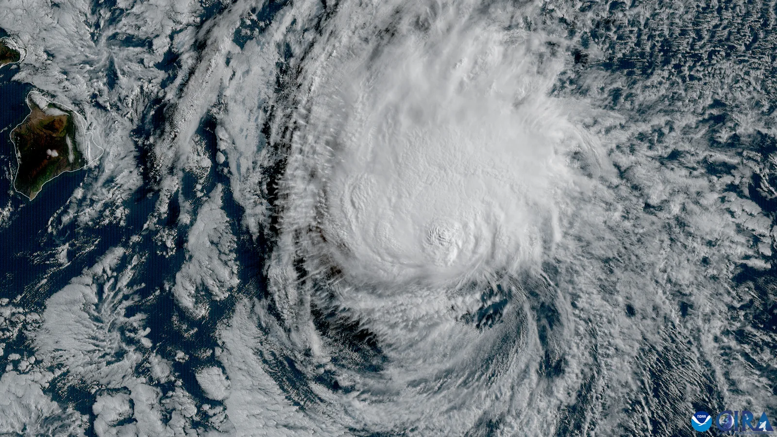
Catastrophic Rainfall and Flash Flood Hazards
While wind speeds capture headlines, the most dangerous threat posed by Tropical Storm Nolo is torrential, prolonged precipitation. Hawaii’s steep volcanic mountains force tropical moisture upward in an orographic lift, wringing out immense quantities of rainfall over short intervals:
- Big Island Rainfall Projections: Forecasts predict 15 to 30 inches of total rainfall across windward and southern slopes, with localized accumulations potentially reaching 35 inches. Areas around Hilo, Puna, Kaʻū, and the Kohala mountain range face high probabilities of life-threatening flash floods and landslides.
- Maui County Projections: Maui is forecast to receive 5 to 10 inches of rain, with isolated mountain peaks recording up to 20 inches, elevating mudslide hazards along the Hana Highway (Route 360).
- Highway Closures: Low-lying segments of the Hawaii Belt Road (Highway 11 and 19) and vulnerable river crossings are prone to swift washouts. Travelers should monitor the Daniel K. Inouye Highway (Saddle Road) between Hilo and Kona, as dense fog, high crosswinds, and sudden downpours can render mountain travel perilous.
Understanding terrain vulnerability is paramount; our foundational guide on flash floods and flood safety protocols highlights why attempting to drive or hike through moving water is the primary cause of weather-related fatalities.
Airline Travel Waivers: Rebooking Without Penalty
In response to Nolo’s projected path, major commercial airlines operating routes into Hawaii have initiated flexible travel waiver policies. Carriers including Hawaiian Airlines, United Airlines, Southwest Airlines, Delta Air Lines, and Alaska Airlines are permitting passengers with tickets booked through Ellison Onizuka Kona International Airport (KOA), Hilo International Airport (ITO), and Kahului Airport (OGG) to alter travel dates without paying change fees or fare differences.
Key airline policies to remember:
- Eligibility Windows: Travel waivers generally cover flights ticketed for travel between September 24 and September 28, 2026.
- Same-Cabin Rule: Rebooked travel must typically occur within a designated rebooking window (often within 7 to 14 days) in the same ticketed cabin class between the same origin and destination cities.
- Proactive Action: If your itinerary involves inter-island flights between Oahu and the Big Island or Maui, rebooking before traveling to the airport eliminates the risk of becoming stranded in transit terminals during ground stops.
National and State Park Closures
Public land managers across the Big Island and Maui have begun rolling closures to safeguard outdoor recreationists:
- Hawaii Volcanoes National Park: Backcountry permits have been suspended, and coastal camping zones (including Halape, Kaʻaha, and Apua Point) are closed. Park rangers are actively monitoring Chain of Craters Road and Mauna Loa Road for prospective closures due to rockfalls and high winds.
- Haleakala National Park: Maui’s summit and coastal Kipahulu districts are monitoring storm tracks, with summit sunrise reservations subject to cancellation if high-altitude winds exceed safe operating thresholds.
- DLNR State Parks: The Hawaii Department of Land and Natural Resources (DLNR) has closed coastal state parks, forest reserve trails, and mountain cabins across the Big Island and East Maui until post-storm damage assessments can be completed.
Essential Hurricane Safety Rules for Tourists
Visitors residing in resort hotels, vacation condominiums, or rural vacation rentals should follow strict safety measures until the storm clears:
- Heed Surf and Ocean Warnings: A massive south-southwest swell is generating hazardous breaking waves of 15 to 25 feet along southern shores. Never approach wet ocean rocks, blowholes, or shorebreak beaches; rogue waves can easily sweep onlookers into turbulent waters.
- Maintain Essential Supplies: Keep mobile devices, external battery banks, and flashlights fully charged in anticipation of localized utility outages. Stock several gallons of bottled drinking water and non-perishable groceries in your accommodation.
- Secure Rental Vehicles: Park rental cars well away from coastal storm surge zones, steep earthen embankments, and overhanging coconut palm trees, which drop heavy fronds and coconuts in gale-force winds.
- Follow Local Civil Defense: Tune radios to local emergency broadcast stations or register for real-time mobile notifications via the Hawaii County Civil Defense Agency and the Maui Emergency Management Agency. Never ignore mandatory evacuation orders for low-lying coastal flood zones.
By staying informed, respecting official park closures, and utilizing airline travel waivers promptly, travelers can navigate Tropical Storm Nolo safely while preserving their Hawaiian travel experience.